According to glaciologists, "There is some evidence to suggest that, in previous interglacials, the West Antarctic Ice Sheet completely disappeared, leading to sea levels about 5m higher than at present [1]. Evidence...indicates open seaways across West Antarctica at various periods during the last few million years, and even during the past one or more interglacials."
Marine ice sheet instability
Introduction | Past evidence of ice sheet collapse | Hypothesis of marine ice sheet instability | References | Comments |
Introduction
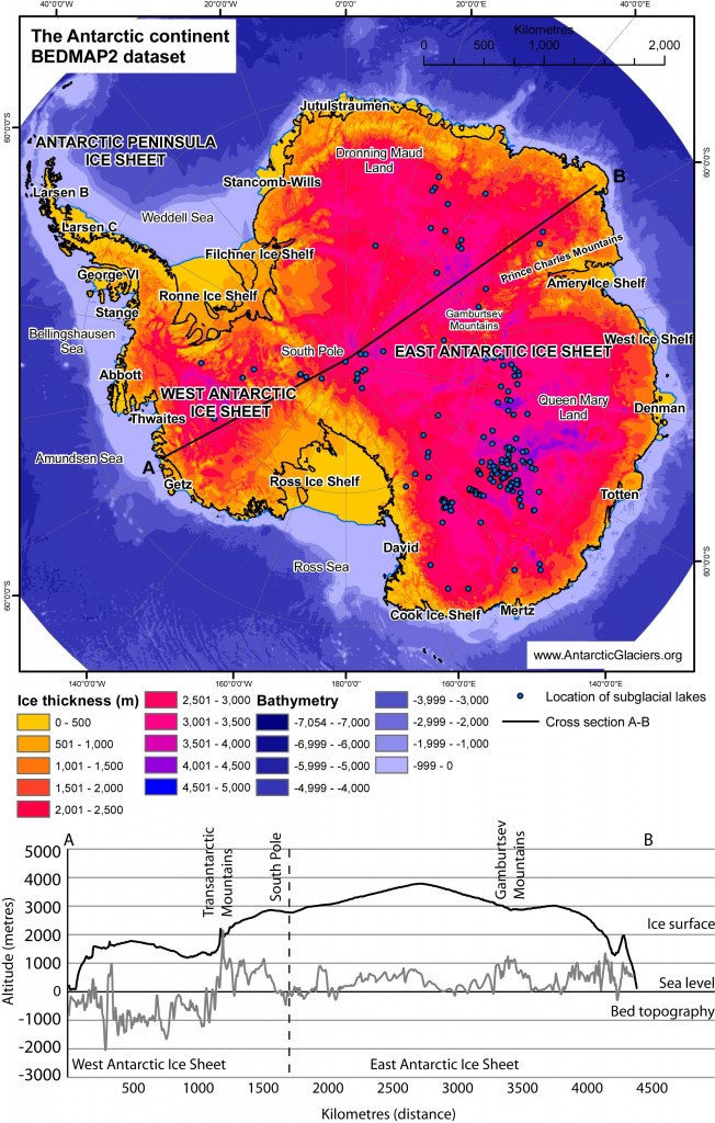
The figure panel opposite shows the Pine Island Glacier and Twaites ice streams, which are grounded well below sea level and drain a large proportion of West Antarctica. Their accumulation areas flow from the Transantarctic Mountains and out into the Amundsen Sea. The map below, from the BEDMAP2 database, shows ice sheet thicknesses and a cross section across the entire Antarctic continent. Here, you can clearly see the difference between the West and East Antarctic ice sheets. They are separated by the 2000 m high Transantarctic Mountains. The East Antarctic Ice Sheet is grounded largely above sea level, whereas the West Antarctic Ice Sheet is mostly grounded well below sea level.In 1978, Mercer was one of the first to identify that rising temperatures could have catastrophic consequences in West Antarctica, triggering a collapse of the West Antarctic Ice Sheet[1]. This is because much of the West Antarctic Ice Sheet lies below sea level[2], making it a Marine Ice Sheet. West Antarctica is currently the world’s largest marine ice sheet, although they may have been common during the Last Glaciation, circa 18,000 years ago. Portions of the Greenland Ice Sheet and East Antarctic Ice Sheet are also marine, but have shallower bathymetries than West Antarctica. The ice sheet is currently stable due to its buttressing ice shelves and local regions where the bathymetry opposes the general trend[3].

The BEDMAP 2 dataset (Fretwell et al. 2013) shows how ice thickness across the Antarctic continent is variable, with thin ice over the mountains and thick ice over East Antarctica. The cross section shows how the West Antarctic Ice Sheet is grounded below sea level.
The figures below show how, firstly, the West Antarctic Ice Sheet is grounded below sea level, and that both the West and East Antarctic Ice sheet have water (lakes and channels) at their base; secondly, bedrock topography of Antarctica; thirdly, ice streams of Antarctica, and fourthly, what the Antarctic continent would look like if all the ice were to be removed. Note how West Antarctica becomes a series of islands.
Past evidence of ice sheet collapse
Hypothesis of marine ice sheet instability
Much of West Antarctica drains through the Pine Island Glacier and Thwaites ice streams into Pine Island Bay. These ice shelves are warmed from below by Circumpolar Deep Water[5], which has resulted in system imbalances, more intense melting, glacier acceleration and drainage basin drawdown[6-8]. This is the “Weak Underbelly” of the West Antarctic Ice Sheet[9], which may be prone to collapse. Pine Island Glacier is currently thinning[10], and, combined with rapid basal melting of the Amundsen Sea ice shelves[11], means that there is concern for the future viability of its fringing ice shelves.
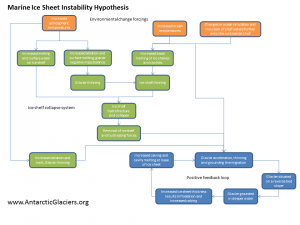
The Marine Ice Sheet Instability hypothesis is that atmospheric and oceanic warming could result in increased melting and recession at the grounding line on a reverse slope gradient[12]. This would result in the glacier becoming grounded in deeper water and a greater ice thickness. This is because the grounding line in this region has a reverse-bed gradient, becoming deeper inland. Stable grounding lines cannot be located on upward-sloping portions of seafloor[13]. Ice thickness at the grounding line is a key factor in controlling flux across the grounding line[3], so thicker ice grounded in deeper water would result in floatation, basal melting, increased iceberg production, and further retreat within a positive feedback loop. This would result in a rapid melting of the West Antarctic Ice Sheet, triggering rapid sea level rise.

Simplified cartoon of a tributary glacier feeding into an ice shelf, showing the grounding line (where the glacier begins to float).
This could be exacerbated by the removal of fringing ice shelves around the Amundsen Sea sector of the West Antarctic Ice Sheet. Removal of buttressing ice shelves around ice streams tends to result in glacier acceleration, thinning, and grounding line migration[14, 15].
This is a low-probability, high-magnitude event, with a 5% probability of the West Antarctic Ice Sheet contributing 10 mm sea level rise per year within 200 years[16]. The most recent numerical models predict a sea level rise of 3.3 m if this event was to occur[12].
This hypothesis has recently featured prominently in the science news, for example, on the Discovery News.


Seal level was 2 to 3 meters higher about 5,000 years ago during the Holocene Climate Optimum (hypsithermal) which probably means that the West Antarctic Ice sheet about half-disappeared then.
ReplyDeleteAs for the losses recently recorded, much of this loss may be explained by the excess thickness during the Little Ice Age.