Showing posts sorted by relevance for query arctic sea ice storm. Sort by date Show all posts

Sunday, August 10, 2014

Arctic sea ice could continue to recover for next 30+ years of negative AMO

The natural ~60-90 year Atlantic Multidecadal Oscillation [AMO] has been in its positive warming phase since 1976 and after ~30+ years of warming is "pausing" and transitioning to its ~30-45 year negative phase [cooling]:


Coincidentally, satellite observations of Arctic sea ice began in 1979 at the start of the positive warming phase of the AMO. The AMO transfers heat from the tropics to the Arctic and melts Arctic sea ice, thus the AMO and Arctic Sea Ice Index are inversely related:


Five year moving average of the Arctic Sea Ice Index [red line] is inversely correlated to the Atlantic Multidecadal Oscillation [AMO] five year moving average shown in green. 
The AMO index "paused" right around the same time global temperatures "paused," perhaps related to solar control of climate and ocean oscillations. 


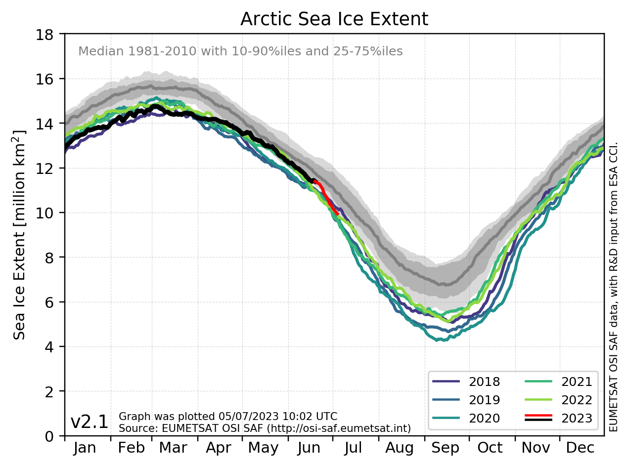
Perhaps this is why Arctic sea ice is having a dramatic recovery this year and is within one standard deviation of the mean:


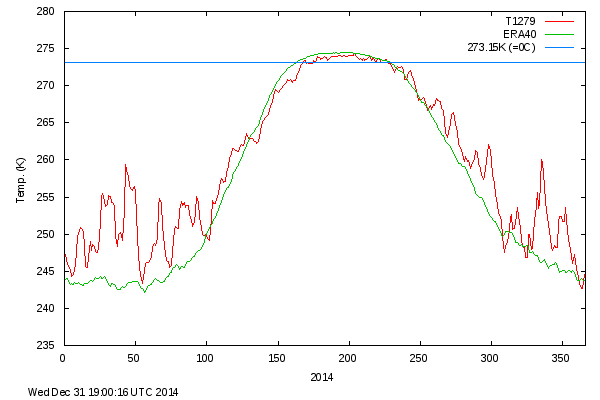
Might this explain why Arctic temperatures have been below the mean every single day during this summer's melt season?:


Thanks to the Arctic sea ice recovery and record high levels of Antarctic sea ice, global sea ice is now back to levels seen 35 years ago


The AMO may now be entering a new ~30-45 year negative phase. If this nutty denier theory is correct, Arctic sea ice could continue to recover for the next 30+ years of the negative phase of the AMO, even if you hang on to your dirty carbon-pollution-spewing SUV. 

Climate experts claim Arctic sea ice and just about everything else in climate is governed by a man-made CO2 "control knob" and most definitely not related to natural ocean oscillations such as the AMO (which in turn are controlled by solar activity), ocean warming from accumulated solar energy, and storm activity. 

Repost:

New paper finds Arctic sea ice is controlled by natural cycles
A paper published today in Geophysical Research Letters finds Arctic sea ice extent is determined primarily by the natural ~60-90 year cycle of the Atlantic Multidecadal Oscillation [AMO], not greenhouse gases.

According to the authors, "Arctic sea ice is intrinsically linked to Atlantic multidecadal [natural] variability" finding a ~60-90 year cycle of "Covariability between sea ice and Atlantic multidecadal variability as represented by the Atlantic Multidecadal Oscillation (AMO) index is evident during the instrumental record."

The paper adds to many other peer-reviewed publications finding changes in Arctic sea ice are primarily related to natural variability of ocean and atmospheric oscillations, storm and wind activity, and not changes in greenhouse gases.

A Signal of Persistent Atlantic Multidecadal Variability in Arctic Sea Ice

Martin W. Miles et al


Satellite data suggest an Arctic sea ice–climate system in rapid transformation, yet its long-term natural modes of variability are poorly known. Here, we integrate and synthesize a set of multi-century historical records of Atlantic Arctic sea ice, supplemented with high-resolution paleo proxy records, each reflecting primarily winter/spring sea ice conditions. We establish a signal of pervasive and persistent multidecadal (~60–90 year) fluctuations that is most pronounced in the Greenland Sea, and weakens further away. Covariability between sea ice and Atlantic multidecadal variability as represented by the Atlantic Multidecadal Oscillation (AMO) index is evident during the instrumental record, including an abrupt change at the onset of the early 20th century warming (ETCW). Similar covariability through previous centuries is evident from comparison of the longest historical sea ice records and paleo proxy reconstructions of sea ice and the AMO. This observational evidence supports recent modelling studies that have suggested that Arctic sea ice is intrinsically linked to Atlantic multidecadal [natural] variability. This may have implications for understanding the recent negative trend in Arctic winter sea ice extent, although because the losses have been greater in summer, other processes and feedbacks are also important.


The AMO, PDO, and NAO have all been linked to solar activity as the driver [possible lunar tidal influence as well].

Wednesday, August 3, 2011

New paper finds Arctic sea ice strongly linked to varying storm activity

Warmists often claim changes in Arctic sea ice are a consequence of allegedly-anthropogenic global warming. However, a paper published today in the Journal of Geophysical Research finds that "dramatic interannual changes" in Arctic sea ice extent are due to varying storm activity in the months of May-July, which impacts "cloud cover and ice motion, and consequently sea ice melt." The authors find fewer cyclones in the Arctic Ocean "appear to favor a low sea ice area at the end of the melt season." Thus, the alleged connection between AGW and Arctic sea ice extent becomes all the more elusive.
JOURNAL OF GEOPHYSICAL RESEARCH, VOL. 116, D15105, 10 PP., 2011

Dramatic interannual changes of perennial Arctic sea ice linked to abnormal summer storm activity 

Key Points:

Interannual changes of Arctic sea ice are related to varying storm activity
Fewer summer storms favor low sea ice at the end of the melt season
Storms impact the cloud cover and ice motion, and consequently sea ice melt

James A. Screen et al

The perennial (September) Arctic sea ice cover exhibits large interannual variability, with changes of over a million square kilometers from one year to the next. Here we explore the role of changes in Arctic cyclone activity, and related factors, in driving these pronounced year-to-year changes in perennial sea ice cover. Strong relationships are revealed between the September sea ice changes and the number of cyclones in the preceding late spring and early summer. In particular, fewer cyclones over the central Arctic Ocean during the months of May, June, and July appear to favor a low sea ice area at the end of the melt season. Years with large losses of sea ice are characterized by abnormal cyclone distributions and tracks: they lack the normal maximum in cyclone activity over the central Arctic Ocean, and cyclones that track from Eurasia into the central Arctic are largely absent. Fewer storms are associated with above-average mean sea level pressure, strengthened anticyclonic winds, an intensification of the transpolar drift stream, and reduced cloud cover, all of which favor ice melt. It is also shown that a strengthening of the central Arctic cyclone maximum helps preserve the ice cover, although the association is weaker than that between low cyclone activity and reduced sea ice. The results suggest that changes in cyclone occurrence during late spring and early summer have preconditioning effects on the sea ice cover and exert a strong influence on the amount of sea ice that survives the melt season.

Sunday, September 14, 2014

New paper links Arctic sea ice extent to absorption of sunlight by clouds

A new paper published in the Journal of Geophysical Research Atmospheres finds Arctic sea ice concentrations at the low of each summer are related to absorption of sunlight by cloud cover at the top of the atmosphere in early summer, a phenomenon "not represented in most of current climate models."

According to the authors, 
"absorbed solar radiation at the top of the atmosphere in early summer (May–July) plays a precursory role in determining the Arctic sea ice concentration in late summer (August–October)"   
"this intimate delayed...relationship is not represented in most of current climate models. Rather, the models tend to over-emphasize internal sea ice processes in summer."
Alarmists focus on Arctic sea ice as the supposed canary in the coal mine for CAGW, but many papers have demonstrated natural variability is more likely responsible for the trends in Arctic sea ice than man-made CO2, including the natural Atlantic Multidecadal Oscillation, Atlantic Meridional Overturning Circulation [AMOC], wind  & storm activity, and long-term solar variability. This new paper suggests another way that natural variability controls Arctic sea ice extent via cloud cover, another possible solar amplification mechanism  via the cosmic ray theory of climate.

Alarmists ignore the unspeakable all-time record highs in Antarctic sea ice extent broken over each of the past three years, as do climate models, which laughably predicted the opposite of a decrease in Antarctic sea ice extent more so than Arctic sea ice. 

Alarmists also claim current Arctic sea ice changes are "unprecedented" while ignoring proxy data indicating Arctic sea ice was much less than present-day during the Holocene Climate Optimum ~6,000 years ago, Arctic temperatures were warmer than the present multiple times over past 1357 years, the Medieval Warming Period in the Arctic was warmer than the present, Alaskan glaciers are about the same size as during the Medieval Warm Period, etc., etc.


Connecting early summer cloud-controlled sunlight and late summer sea ice in the Arctic


Yong-Sang Choi, Baek-Min Kim, Sun-Kyong Hur, Seong-Joong Kim, Joo-Hong Kim, Chang-Hoi Ho

This study demonstrates that absorbed solar radiation (ASR) at the top of the atmosphere in early summer (May–July) plays a precursory role in determining the Arctic sea ice concentration (SIC) in late summer (August–October). The monthly ASR anomalies are obtained over the Arctic Ocean (65°N–90°N) from the Clouds and the Earth's Radiant Energy System during 2000–2013. The ASR 
[absorbed solar radiation] changes primarily with cloud variation. We found that the ASR [absorbed solar radiation] anomaly in early summer is significantly correlated with the SIC [Arctic sea ice concentration] anomaly in late summer (correlation coefficient, r ≈ −0.8 with a lag of 1 to 4 months). The region exhibiting high (low) ASR anomalies and low (high) SIC anomalies varies yearly. The possible reason is that the solar heat input to ice is most effectively affected by the cloud shielding effect under the maximum TOA solar radiation in June and amplified by the ice-albedo feedback. This intimate delayed ASR-SIC relationship is not represented in most of current climate models. Rather, the models tend to over-emphasize internal sea ice processes in summer.

Saturday, August 25, 2012

Paper finds Arctic sea ice extent 8,000 years ago was less than half of the 'record' low 2007 level

A paper published in Science finds summer Arctic Sea Ice extent during the Holocene Thermal Maximum 8,000 years ago was "less than half of the record low 2007 level." The paper finds a "general buildup of sea ice from ~ 6,000 years before the present" which reached a maximum during the Little Ice Age and "attained its present (year 2000) extent at 4,000 years before the present"
 
Horizontal axis is number of years before the present. Multiyear sea ice reached a minimum between ~8500-6000 years ago during the Holocene Thermal Maximum (HTM).
Excerpt: In general, our sea-ice record for North Greenland follows the Holocene climate development, with an early warm period followed by declining temperatures, which were punctuated by relatively warmer and colder intervals (17, 25). The reduction of the HTM sea ice in northern Greenland fits with the simulated ice distribution and surface temperature in orbitally forced ECHAM5/JSBACH/MPI-OM (EJM) and LOVECLIM general circulation climate model simulations (3, 4, 10). A tentative first approximation of the large-scale changes associated with the observed ice retreat north of Greenland can be obtained by selecting among the numerical experiments performed with the LOVECLIM model those that are the most similar to our observations [experiments E3 to E5 (3) and fig. S3]. In this exercise, our records would correspond in the model to an Arctic Ocean sea-ice cover in summer at 8 ky B.P. that was less than half of the record low 2007 level. The general buildup of sea ice from ~6 ky B.P. agrees with the LOVECLIM model, showing that summer sea-ice cover, which reached its Holocene maximum during the LIA, attained its present (~2000) extent at ~4 ky B.P. (fig. S3)

Science
Vol. 333 no. 6043 pp. 747-750 
DOI: 10.1126/science.1202760
  • REPORT

A 10,000-Year Record of Arctic Ocean Sea-Ice Variability—View from the Beach

ABSTRACT

We present a sea-ice record from northern Greenland covering the past 10,000 years. Multiyear sea ice reached a minimum between ~8500 and 6000 years ago, when the limit of year-round sea ice at the coast of Greenland was located ~1000 kilometers to the north of its present position. The subsequent increase in multiyear sea ice culminated during the past 2500 years and is linked to an increase in ice export from the western Arctic and higher variability of ice-drift routes. When the ice was at its minimum in northern Greenland, it greatly increased at Ellesmere Island to the west. The lack of uniformity in past sea-ice changes, which is probably related to large-scale atmospheric anomalies such as the Arctic Oscillation, is not well reproduced in models. This needs to be further explored, as it is likely to have an impact on predictions of future sea-ice distribution.
Related: New paper finds Arctic sea ice strongly linked to varying storm activity

Monday, December 16, 2013

New paper finds Arctic sea ice is controlled by natural cycles

A paper published today in Geophysical Research Letters finds Arctic sea ice extent is determined primarily by the natural ~60-90 year cycle of the Atlantic Multidecadal Oscillation [AMO], not greenhouse gases.

According to the authors, "Arctic sea ice is intrinsically linked to Atlantic multidecadal [natural] variability" finding a ~60-90 year cycle of "Covariability between sea ice and Atlantic multidecadal variability as represented by the Atlantic Multidecadal Oscillation (AMO) index is evident during the instrumental record."

The paper adds to many other peer-reviewed publications finding changes in Arctic sea ice are primarily related to natural variability of ocean and atmospheric oscillations, storm and wind activity, and not changes in greenhouse gases.

A Signal of Persistent Atlantic Multidecadal Variability in Arctic Sea Ice

Martin W. Miles et al
Satellite data suggest an Arctic sea ice–climate system in rapid transformation, yet its long-term natural modes of variability are poorly known. Here, we integrate and synthesize a set of multi-century historical records of Atlantic Arctic sea ice, supplemented with high-resolution paleo proxy records, each reflecting primarily winter/spring sea ice conditions. We establish a signal of pervasive and persistent multidecadal (~60–90 year) fluctuations that is most pronounced in the Greenland Sea, and weakens further away. Covariability between sea ice and Atlantic multidecadal variability as represented by the Atlantic Multidecadal Oscillation (AMO) index is evident during the instrumental record, including an abrupt change at the onset of the early 20th century warming (ETCW). Similar covariability through previous centuries is evident from comparison of the longest historical sea ice records and paleo proxy reconstructions of sea ice and the AMO. This observational evidence supports recent modelling studies that have suggested that Arctic sea ice is intrinsically linked to Atlantic multidecadal [natural] variability. This may have implications for understanding the recent negative trend in Arctic winter sea ice extent, although because the losses have been greater in summer, other processes and feedbacks are also important.

Saturday, March 1, 2014

New paper finds lows of Arctic sea ice in 2007 and 2012 were due to storms

A new paper published in The Cryosphere finds that the 2 recent lows in Arctic sea ice over the past decade during 2007 and 2012 were strongly related to storm activity, rather than a long-term effect of climate change. According to the authors, "Strong summer storms on the Siberian side of the Arctic Ocean may have been important contributions to the recent [Arctic sea ice minimums] in 2007 and 2012." Arctic sea ice strongly rebounded in 2013 by up to 78% in comparison to 2012, suggesting the 2007 and 2012 lows were just natural variation. 

The paper adds to many other peer-reviewed publications finding Arctic sea ice extent is due to natural variability from winds and storms, not AGW.

The Arctic sea ice minimums in 2007 [purple] and 2012 [orange] were strongly related to storm activity, not AGW.

The Cryosphere, 8, 303-317, 2014
www.the-cryosphere.net/8/303/2014/
doi:10.5194/tc-8-303-2014


A. Kriegsmann1,* and B. Brümmer1
1Meteorological Institute, University of Hamburg, Hamburg, Germany
*now at: Climate Service Center, Hamburg, Germany

Abstract. This study investigates the impact of cyclones on the Arctic Ocean sea ice for the first time in a statistical manner. We apply the coupled ice–ocean model NAOSIM which is forced by the ECMWF analyses for the period 2006–2008. Cyclone position and radius detected in the ECMWF data are used to extract fields of wind, ice drift, and concentration from the ice–ocean model. Composite fields around the cyclone centre are calculated for different cyclone intensities, the four seasons, and different sub-regions of the Arctic Ocean. In total about 3500 cyclone events are analyzed. In general, cyclones reduce the ice concentration in the order of a few percent increasing towards the cyclone centre. This is confirmed by independent AMSR-E satellite data. The reduction increases with cyclone intensity and is most pronounced in summer and on the Siberian side of the Arctic Ocean. For the Arctic ice cover the cumulative impact of cyclones has climatologic consequences. In winter, the cyclone-induced openings refreeze so that the ice mass is increased. In summer, the openings remain open and the ice melt is accelerated via the positive albedo feedback. Strong summer storms on the Siberian side of the Arctic Ocean may have been important contributions to the recent ice extent minima in 2007 and 2012.

Saturday, June 22, 2013

New paper finds another natural mechanism controlling Arctic sea ice extent

A new paper published in the International Journal of Climatology finds 40-79% of the variation in western Arctic sea ice extent is due to natural atmospheric circulation patterns such as the Arctic Dipole (AD), Arctic Oscillation (AO), and Pacific-North American (PNA) pattern. Prior research has shown Arctic sea ice extent is also controlled by natural variation of winds and storm activity, and related to the geography of the Arctic, not alleged anthropogenic global warming. 

Associations between circulation pattern frequencies and sea ice minima in the western Arctic

Thomas J. Ballinger, Scott C. Sheridan

ABSTRACT: In this study, a synoptic climatological approach is employed to assess the relationship between the frequency of circulation patterns (CPs) and the latitude of mid-September sea ice minima in the western Arctic. Fifteen CPs are created via principal component analysis and cluster analysis from daily NCEP/NCAR reanalysis sea-level pressure (SLP) fields across a grid from 50 to 90°N and 150°E–100°W from 1979 to 2011. The frequency of these CPs are statistically compared with the latitude of the sea ice minimum from passive microwave data for each of 11 equally-spaced longitudes (176°W to 126°W) extending into the Chukchi and Beaufort Seas. Monthly frequencies for each of the 15 CPs from March to September, signifying the melt season, for each year are correlated with the ice minimum for that September. These monthly frequencies are then entered into a stepwise multiple linear regression (SMLR) and collectively, CP [
circulation pattern] frequencies explain 40–79% of the total ice retreat variance across the longitudes. The frequency of one cluster, CP 11, representing a broad high pressure area over the Beaufort Sea, is highly correlated with the latitude of the sea ice minima; June and August frequencies of this pattern are the initial predictors at 8 of the 11 longitudes and explain 22–32% of the variance. This pattern has occurred more frequently from 2007 onwards; compared with a June mean occurrence of 9 days during 1979–2006, CP 11 occurred 16 times in June 2007, and on average more than 17 days per month during June 2008–2011. The Arctic Dipole (AD), Arctic Oscillation (AO), and Pacific-North American (PNA) pattern indices are significantly correlated with CPs 11–13 frequencies throughout certain summer months, further indicating strong relationships between summer circulation and sea ice minima in the region.

Wednesday, July 17, 2013

Paper finds Arctic climate & sea ice extent related to solar activity

A paper published by the Danish Meteorological Institute finds a remarkable correlation of Arctic sea ice observations over the past 500 years to "the solar cycle length, which is a measure of solar activity. A close correlation (R=0.67) of high significance (0.5 % probability of a chance occurrence) is found between the two patterns, suggesting a link from solar activity to the Arctic Ocean climate." The paper adds to several others demonstrating that Arctic sea ice extent and climate is controlled by natural variations in solar activity, ocean & atmospheric oscillations, winds & storm activity, not man-made CO2.


Solar Cycle Length [SCL] shown by dotted line, Koch sea ice extent index from observations in the Greenland Sea shown by solid line.
Multi-decadal variation of the East Greenland Sea-Ice Extent: AD 1500-2000

Knud Lassen and Peter Thejll

Abstract: The extent of ice in the North Atlantic varies in time with time scales stretching to centennial, and the cause of these variations is discussed. We consider the Koch ice index which describes the amount of ice sighted from Iceland, in the period 1150 to 1983 AD. This measure of ice extent is a non-linear and curtailed measure of the amount of ice in the Greenland Sea, but gives an overall view of the amounts of ice there through more than 800 years. The length of the series allows insight into the natural variability of ice extent and this understanding can be used to evaluate modern-day variations. Thus we find that the recently reported retreat of the ice in the Greenland Sea  may be related to the termination of the so-called Little Ice Age in the early twentieth century. We also look at the approximately 80 year variability of the Koch [sea ice] index and compare it to the similar periodicity found in the solar cycle length, which is a measure of solar activity. A close correlation (R=0.67) of high significance (0.5 % probability of a chance occurrence) is found between the two patterns, suggesting a link from solar activity to the Arctic Ocean climate.

Tuesday, February 24, 2015

Why media hype on AGW shifting the jet stream is "premature"

Science

Vol. 347 no. 6224 pp. 818-821 

DOI: 10.1126/science.347.6224.818
  • Feature

Arctic impact

Weather experts were on high alert in December 2009. A region of high pressure had settled over Greenland, forming a roadblock in the path of the circumpolar jet stream. Thwarted, the jet stream meandered, bending southward into a large loop and shunting cold Arctic air toward the center of the United States. Meteorologists were familiar with this “Greenland block.” It was a climate pattern historically favorable for winter storms—and as if on cue, record snowfalls blanketed the eastern United States over the next few months.
Against the backdrop of “Snowmageddon” and other powerful winter storms that have blasted the United States, Europe, and Asia in the past few years, a different kind of tempest has been swirling within the Arctic science community. Its core is a flurry of recent research proposing that such extreme weather events in the midlatitudes are linked through the atmosphere with the effects of rapid climate change in the Arctic, such as dwindling sea ice. The idea has galvanized the public and even caught the attention of the White House. But some Arctic researchers say the data don't support it or that the jury is at least still out. Even some of its proponents agree that the media hype is premature.
Now, scientists are starting to tackle the issue in earnest. Atmospheric links between the poles and midlatitudes are becoming a marquee topic at Arctic-related conferences. Last December alone it drew researchers to a workshop in Barcelona, Spain, and a dedicated session at the annual American Geophysical Union meeting in San Francisco, California. “A lot of scientists have worked individually, in isolation, pursuing their own ideas,” says Judah Cohen, a climate scientist at the Massachusetts Institute of Technology in Cambridge—one of several researchers who hope that a coordinated effort will measure the reach of the north.
THE IDEA THAT THE ARCTIC could have a regional, even hemisphere-scale impact on the atmosphere represents a paradigm shift for climate scientists. “When I was in grad school, [the thinking was that] the tropics are everything,” Cohen says. “The tropics, the ocean—that was it, there was no other player.”
The Arctic Ocean, after all, is small and cold; the tropical Pacific Ocean is vast and, of course, warmer. To influence the atmosphere on a global scale, very large amounts of heat and moisture must flow from ocean to air. That heat engine is huge in the Pacific and powers the El Niño–Southern Oscillation (ENSO), the planet's dominant interannual climate pattern. ENSO also has a helpful supply chain: Even as heat escapes from the eastern tropical Pacific to the atmosphere, currents flowing in from the western tropical Pacific provide a fresh supply.
But there is a new kind of engine forming in the Arctic. The rapid loss of sea ice in the Arctic Ocean due to global warming—the area of summer ice has shrunk more than 11% per decade since 1979—has created an expanse of dark open water newly available to absorb the sun's energy. This extra energy input and the corresponding flux of moisture and heat to the Arctic atmosphere are helping drive a strong local positive feedback to global warming, called Arctic amplification. As a result, surface temperatures are rising twice as fast in the Arctic as at lower latitudes.
Heavy blizzards that paralyzed Central Europe in February 2012 may have been part of a larger pattern.
PHOTO: © BOGDAN CRISTEL/REUTERS/CORBIS
But is the loss of sea ice influencing more than just local warming? In 2012, climatologists Jennifer Francis of Rutgers University, New Brunswick, in New Jersey and Stephen Vavrus of the University of Wisconsin, Madison, proposed that Arctic amplification driven by sea ice loss could significantly affect midlatitude weather by slowing the jet stream (Science, 18 April 2014, p. 250). The mechanism they suggested was this: A faster warming Arctic means a reduced temperature gradient between the Arctic and midlatitudes, which in turn weakens west-to-east winds. The result is a slowdown of the jet stream, allowing it to meander more and form elongated waves (called Rossby or planetary waves) that jut to the north or south. Among other effects, Francis and Vavrus proposed, the deep waves in the jet stream could enable a winter storm to push farther south and then linger in one location, possibly dumping record amounts of snow.
A handful of newer studies support one key part of this hypothesis: that large-amplitude Rossby waves in the jet stream are indeed linked, statistically, to extreme weather in the midlatitudes. For example, Vladimir Petoukhov of the Potsdam Institute for Climate Impact Research in Germany and colleagues in 2013 correlated summer heat waves in Europe with instances of slow-moving, high-amplitude Rossby waves. And last year, James Screen, a climate modeler at the University of Exeter in the United Kingdom, and Ian Simmonds of the University of Melbourne in Australia co-authored a paper that reported a strong statistical correlation between amplified, slow Rossby waves and months from 1979 to 2012 with extreme weather events. More waviness, they found, made the western United States more susceptible to heat waves and the eastern United States to extreme cold.
But other parts of the hypothesis remain controversial—particularly the part of the chain that links these changes to Arctic amplification. Some evidence supports Francis and Vavrus's idea that a decreasing temperature gradient between the midlatitudes and the Arctic might slow the jet stream and make it wavier.
Yet climate dynamicist Elizabeth Barnes of Colorado State University, Fort Collins, reported in 2013 that she could find no uptick in the instances of Rossby waves in the last couple of decades, the period encompassing extreme sea ice loss and Arctic warming. And in a 2013 study, Screen and Simmonds found no statistically significant changes in these waves from 1979 to 2011, despite a declining north-south temperature gradient.
Some theorists have proposed another mechanism by which dwindling sea ice could shape midlatitude weather: by forcing changes in a multiyear atmospheric cycle called the Arctic Oscillation. In a positive Arctic Oscillation phase, the jet stream is strong and less wavy, and cold air stays in the Arctic. In a negative phase, the jet stream is weaker and wavier, and the cold air spills southward. Some analyses suggest that in the last few decades the Arctic Oscillation has increasingly been in a negative phase, which might drive not just storminess but also longer term cooling in the midlatitudes.
But evidence that the retreat of sea ice has influenced the Arctic Oscillation is scarce. “Since any Arctic effect [on the jet stream] is buried in large random climate [variations], and the record is short,” such a link is simply impossible to prove at the moment, says James Overland, an oceanographer at the National Oceanic and Atmospheric Administration's Pacific Marine Environmental Laboratory in Seattle, Washington.
FRANCIS ACKNOWLEDGES the lingering uncertainty about how the changes in the Arctic could drive bouts of extreme weather farther south. But, she says, as the mystery attracts more researchers, they are finding clues. Last year, climate scientist Masato Mori of the University of Tokyo and colleagues modeled how sea ice loss in the Barents and Kara seas north of Russia could increase blocking events—and the resulting severe winters—over Eurasia. And Baek-Min Kim of the Korea Polar Research Institute in Incheon and colleagues showed in a model how changes in sea ice loss in the Barents and Kara seas could set off a chain of events that produced a negative phase of the Arctic Oscillation.
Another paper published last year, this one by Kazutoshi Sato of the Japan Agency for Marine-Earth Science and Technology in Yokosuka and colleagues, suggests that ice loss in the Barents Sea and cold Eurasian winters are actually part of an even bigger climate pattern originating in the North Atlantic Gulf Stream. Recent observations show that the current is pushing warm water farther to the north. That shift, Sato and his colleagues found, may produce planetary waves that both warm the Barents Sea and cause a cold anomaly over Eurasia.
“That's a pretty robust linkage there,” Francis says. “It's not going to happen every single year, but it's pretty convincing that there are real physical mechanisms disrupting the jet stream.”
IT'S TOO EARLY TO TAKE SIDES about whether the Arctic influence is real, many researchers say. Last December's Barcelona workshop grappled with that “two camps” misconception, Screen says. “I don't like to frame it like that,” he says. “The majority [of people] are somewhere in the middle.” In fact, a few are in an entirely different camp: blaming changes in Eurasian snow cover, rather than the retreat of Arctic ice, for the midlatitude weather extremes (see sidebar, p. 821).
“We have records of sea ice only going back 30 years, with dramatic losses in the last decade or so,” Screen says. A statistical analysis of that brief period of observations, he says, is unlikely to settle the debate. Instead, scientists need to turn to other sources of knowledge, such as models and theory, “to better understand what we might be seeing in the observations.”
Overland, for his part, calls this the “preconsensus period.” He says meetings such as the workshop in Barcelona (which both he and Screen attended) have shown encouraging signs of progress. For one, researchers plagued by inconsistent definitions of terms such as waviness are finally getting a chance to straighten things out. And he felt that the Barcelona workshop did come to at least one consensus: that if there are links between Arctic amplification and midlatitude weather, they're amplifications of already existing and known climate patterns—Greenland blocking and a region of persistent high pressure called the Siberian high—so there's no need to build brand-new physics into the models.
SORTING OUT THOSE “known knowns” is exactly what researchers should be doing, Barnes says. “In my mind, we've put the cart before the horse a bit” by focusing on weather extremes, she says. “We're missing the theory, the dynamics, the mechanistic understanding.” She suggests that the community go back to basics to determine how Arctic warming could influence the jet stream dynamics. “It's certainly not sexy like telling you that we're going to have more extreme cold events—but in terms of the science, it's the way forward.”
One key to success, she says, is teasing out the effects of the Arctic on the jet stream from those of other atmospheric powerhouses, such as the chaotic atmospheric flow at midlatitudes and the ENSO pattern in the tropics. Indeed, researchers need to look beyond the potential impacts of Arctic change, Overland says, and aim for a better picture of atmospheric dynamics as a whole.
“We're just getting into that time where people get interested,” Barnes says. “If you look over the literature in the last 10 years, there's a lot of focus over how tropical warming will influence the jet stream, but not a lot on how Arctic warming will influence it. As a community our eyes were turned to the south, and now we're looking north. That, to me, is what's exciting.”
Sunday, March 16, 2014

Media claims that "Greenland's ice loss has tripled in a decade" are CAGW propaganda

The CAGW alarmist media is awash today with claims based on a paper published in Nature Climate Change that "Greenland's ice loss has nearly tripled in a decade" and "the Greenland ice sheet has lost it's last grip." As usual, the paper has been hyped by the media to portray impending doom, while examination of the actual scientific paper reveals very little of concern. 

Figure 1a shows the tiny region of Greenland that the paper studied, with a blowup of this region in figure 2 below. The authors find an increase in the natural glacier calving process in this regional, relatively tiny portion of the Greenland ice sheet. According to the authors, this is due to regional warming found at the site "HKH" marked by an "X" in fig. 2a below. The key word here is regional, which indicates these processes are localized and not characteristic of global warming. In fact, the authors also looked at another nearby site "DH" marked by an "X" in fig. 2a below and found that this site cooled over the past decade.

Examination of Figure 2 below reveals that over the past 34 years 1978-2012:
  • Annual sea surface temperature anomaly has cooled at both sites DH and HKH
  • June-August summer temperatures sswarmed at site HGH but cooled at site DH, and are only about 2C above the freezing point
  • Annual air temperatures at both sites increased, but are about 10 degrees cooler than the freezing point
These localized, regional changes were not predicted by climate models and are not supportive of the CAGW meme, and in fact suggest that other processes are responsible. For example, geothermal sources have recently been discovered under the Greenland ice sheet, which create lakes under the ice sheet and lubricate the natural slide to calving in the ocean. In addition, storm activity and winds largely control Arctic sea ice, which can act as an impediment to glacier calving. 


Greenland Ice Sheet Loses Its Last Grip


Sustained mass loss of the northeast Greenland ice sheet triggered by regional warming


Nature Climate Change   (2014)   doi:10.1038/nclimate2161

Abstract


The Greenland ice sheet has been one of the largest contributors to global sea-level rise over the past 20 years, accounting for 0.5 mm yr−1 of a total of 3.2 mm yr−1. A significant portion of this contribution is associated with the speed-up of an increased number of glaciers in southeast and northwest Greenland. Here, we show that the northeast Greenland ice stream, which extends more than 600 km into the interior of the ice sheet, is now undergoing sustained dynamic thinning, linked to regional warming, after more than a quarter of a century of stability. This sector of the Greenland ice sheet is of particular interest, because the drainage basin area covers 16% of the ice sheet (twice that of Jakobshavn Isbræ) and numerical model predictions suggest no significant mass loss for this sector, leading to an under-estimation of future global sea-level rise. The geometry of the bedrock and monotonic trend in glacier speed-up and mass loss suggests that dynamic drawdown of ice in this region will continue in the near future.

Introduction


Mass loss from the Greenland ice sheet (GrIS) is regionally distributed between sectors manifesting quite different sensitivities to external forcings1, 2, 3. Enhanced surface melting and dynamic thinning associated with the speed-up of glacier flow1 is mainly concentrated in the southest, west and northwest parts of the GrIS (refs 4, 5, 6, 7, 8, 9, 10, 11, 12, 13, 14), where most of the ice margin is in contact with the ocean. In southwest Greenland, where the ice sheet margin is typically located up to 100 km inland, there are few marine-terminating glaciers and mass loss is dominated by atmospheric forcing1. In contrast, major marine-terminating outlet glaciers characterize the northeast sector of Greenland, but these glaciers are surrounded by year-round sea ice, which suppresses calving front retreat15.
Many of the glaciers in southeast, west and northwest Greenland that experienced dynamic thinning in 2003 and 2005, respectively, have somewhat slowed down in recent years7, 8, 16. However, the two glaciers with the largest contributions to GrIS mass loss—Jakobshavn Isbræ (JI) and Kangerdlugssuaq Glacier (KG)—have maintained their high rate of mass loss throughout the past decade11 (Fig. 1a–c and Table 1). Both glaciers possess a negative bed slope17, 18 (a bed that deepens inland) that lies below sea level, the key conditions for satisfying the marine ice sheet instability hypothesis associated with parts of west Antarctica19, 20, 21. However, a far more substantive (by area) marine-based sector (Fig. 1) lies at the mouth of the >600-km-long northeast Greenland ice stream22, 23, 24 (NEGIS), with its three main outlets, the Nioghalvfjerdsfjorden Glacier (NG) also called 79 North, the Zachariae Isstrøm (ZI) and Storstrømmen Glacier (SG) (Fig. 2a). NG is characterized by its almost 80-km-long and 20-km-wide floating tongue, widening to about 30 km at the calving front22, 23, 24, 25, 26. ZI has an almost 30-km-long calving front and is grounded at present. Both glaciers are located at the northeastern corner of the GrIS near Fram Strait and the Nordic Sea and are exposed to ocean variability22. They both have fast (>1 km yr−1) near-terminus velocities. SG is located about 200 km south of ZI and has a 20-km-wide calving front. However, SG diverges into two lobes, one which calves directly into the ocean, whereas the other merges with Bistrup Glacier (BG). Both lobes have slow (~100 m yr−1) near-terminus velocities.


Figure 1: Changes in surface elevations obtained using ICESat, ATM, LVIS and ENVISAT data (Supplementary Section 1.0).
Changes in surface elevations obtained using ICESat, ATM, LVIS and ENVISAT data (Supplementary Section 1.0).
a–c, Ice surface elevation change rates in m yr−1 from April 2003 to April 2006 (a), April 2006 to April 2009 (b) and April 2009 to April 2012 (c).


Table 1: Ice mass loss rates.


Figure 2: Surface speed, mass loss rates and climate data.
Surface speed, mass loss rates and climate data.
a, colours indicate ice speed in m yr−1 during winter 2008–2009 (Supplementary Information). Triangles denote locations of GPS stations and their vertical accelerations in mm yr−2. Squares and crosses denote locations of ocean and meteorological points, respectively. b, Ice mass rate from 1978 to 2012, grey shaded vertical bars represent three-year intervals (2003–2006, 2006–2009, 2009–2012) from April to April.c, Subsurface water temperature anomaly in °C after removing the 1961–1990 baseline. d, Sea surface temperature anomaly in °C after removing the 1961–1990 baseline. e, Mean summer air temperature in °C. JJA: June, July August. f, Red time series represents Danmarkshavn (DH), purple time series represents HKH, mean annual air temperature in °C. Each coloured line in c–f corresponds to a coloured square or cross in a.
Here we use repeat measurements of surface elevation over the entire GrIS to estimate dynamic thinning at marine margins (Fig. 1a–c and Supplementary Section 1.0). Our results show that the NEGIS was relatively stable for at least a quarter of a century, followed by rapid dynamic thinning starting some time between 2003 and 2006. To investigate possible forcing mechanisms capable of triggering such instability, we analyse surface and subsurface water temperature, near-surface air temperature variations and sea ice concentrations
We map elevation changes from April 2003 to April 2012 using altimeter surveys from the National Aeronautics and Space Administration’s airborne topographic mapper (ATM) flights from 2003 to 2012 (ref. 27) supplemented with ice, cloud and land elevation satellite (ICESat) laser altimeter data from 2003 to 2009 (ref. 28), land, vegetation and ice sensor (LVIS) data from 2007 to 2012 (ref. 29) and European Space Agency Environmental Satellite (ENVISAT) data from April 2009 to March 2012 (ref. 30). To assess thinning before 2003, we produced a 25 × 25 m gridded digital elevation model using aerial photographs31 from 1978 that cover the coastal portion of the northeast sector of Greenland (Fig. 2a and Supplementary Section 3.1).

Ice-sheet-wide mass loss


Mass loss rates calculated for the entire GrIS reveal a dramatic increase in loss caused by surface mass balance (SMB) between April 2003 and April 2012, and a complex contribution from dynamic mass loss (Table 1).
The average ice-sheet-wide mass loss increased from 172.4 ± 21.7 Gt yr−1 during April 2003–April 2006 to 359.8 ± 28.9 during April 2009–April 2012. The increase is due to a combination of increased dynamic mass loss and SMB-inferred mass loss. To estimate mass loss due to changes in ice dynamics, we subtract the SMB-inferred mass loss (obtained using the regional climate model RACMO2; ref. 32) from the observed mass loss rate. Dynamically driven mass loss rates increased from 129.7 ± 22.7 Gt yr−1 during April 2003–April 2006, to 156.3 ± 40.9 Gt yr−1 during April 2009–April 2012. This increase is mainly due to the acceleration of several outlet glaciers experiencing speed-up4, 5, 8. However, cases of glacier slowdown are reported11, for example, at Helheim Glacier (HG) where dynamically driven mass loss decreased from 7.0 ± 1.0 Gt yr−1 during April 2003–April 2006, to −1.2 ± 1.2 Gt yr−1 during April 2009–April 2012. The other two main outlet glaciers in south Greenland, JI and KG, have kept their high rate of dynamically driven mass loss (>10 Gt yr−1) throughout the past decade. In north Greenland, the NEGIS basin has increased its contribution to dynamically driven mass loss to more than 10 Gt yr−1 during April 2006–April 2012, a mass loss rate similar to JI after its speed-up in the late 1990s (ref. 33; Table 1). Estimation of ice flux rate for NG and ZI suggest an increase of ice flux by 9.8 ± 3.0 Gt yr−1 during February–April 2011 relative to winter 2000–2001. The flux rate for ZI increased further in 2012 (Supplementary Table 4).

Thinning of the northeast Greenland ice sheet since 1978


The average ice surface elevation change rates for coastal portions of the NEGIS between 1978 and 2003 are displayed in Fig. 3a. The 1978 digital elevation model, based on aerial photographs, is limited to areas below the snow line (within roughly 100 km of the ice margin), because the low contrast over snow prevents data sampling. To estimate elevation change rates between 1978 and 2003, we use aerial photography from 1978 and ICESat data from 2003. Fig. 3a shows only minor elevation change rates during 1978–2003, suggesting this sector of the GrIS had been relatively stable for at least 25 years preceding 2003 (Table 1). This conclusion is further supported by sparse ATM data between 1995 and 1999 (Supplementary Section 3.1.2). Fig. 3b shows that this stable period was followed by relatively localized fluctuations in elevation change rates during April 2003–April 2006. However, more pervasive and pronounced thinning rates are observed from April 2006 to April 2009 (Fig. 3c) and continue uninterrupted throughout April 2009–April 2012 (Fig. 3d). Thinning rates of more than 1 m yr−1 cover an area of 840 km2 by April 2003–April 2006, 5,946 km2 by April 2006–April 2009 and 7,747 km2 by April 2009–April 2012. Fig. 3e, f shows SMB-induced thinning rates for the same periods as in Fig. 3a–d. The thickening from 2003 to 2012 on SG and BG (two dome-like features located 60–100 km upstream from the main glacier flow line) is probably due to the buildup of mass in their reservoir area following the surges of the two glaciers during 1978–1984 (refs 34, 35).


Figure 3: Surface elevation change rates in northeast Greenland using aerial photographs, ICESat, ATM, LVIS and ENVISAT data.
Surface elevation change rates in northeast Greenland using aerial photographs, ICESat, ATM, LVIS and ENVISAT data.
a–d, Observed ice surface elevation change rates in m yr−1 during August 1978–April 2003 (a), April 2003–April 2006 (b), April 2006–April 2009 (c) and April 2009–April 2012 (d). e–h, Total elevation change rates in m yr−1 owing to SMB fluctuations using regional climate model RACMO2 including firn compaction during August 1978–April 2003 (e), April 2003–April 2006 (f), April 2006–April 2009 (g) and April 2009–April 2012 (h). i–l,  Dynamically driven elevation change rates in m yr−1 during August 1978-April 2003 (i), April 2003–April 2006 (j), April 2006–April 2009 (k) and April 2009–April 2012 (l).
Accelerated mass loss associated with the NEGIS is further documented by continuous global positioning system (GPS) receivers established on bedrock to measure vertical surface displacement driven by the changes in ice loads36. All stations in the northeast sector of the Greenland GPS Network37 are uplifting owing to some combination of the Earth’s instantaneous elastic response to contemporary changes in ice mass and its delayed viscoelastic response to past changes in ice mass. However, accelerations in uplift can be attributed only to contemporary accelerations in ice mass losses. GPS data from 2008 to 2013 record accelerating uplift (Fig. 2a) caused by increasing mass loss centered at the front of ZI. Combined with the elevation data this strongly supports the conclusion that ZI mass loss has been accelerating since at least 2003 and was ongoing through 2013.

Acceleration and retreat


Fig. 4a, b shows positions of calving fronts at various times between 1978 and 2012. The 1978 calving front is obtained from aerial photos, whereas the 1999–2012 fronts are based on Land Remote-Sensing Satellite System images from http://glovis.usgs.gov andhttp://earthexplorer.usgs.gov. All images were recorded in July or August. The front of NG retreated by 5–7 km during 1978 and 2003, but was at more or less the same position between 2003 and 2009 (ref. 38). During 2009–2012 the southern tip and the mid-section retreated by 2–3 km. The retreat took place at the floating tip of the glacier. The frontal portion of ZI broke off during 2002. The break-off did not result in thinning, probably owing to low lateral resistance15. The ZI retreated in 2002 and caused minor thinning near the front. However, once the portion of the glacier that is in deeper water (Fig. 4c) started to retreat in 2005–2006 (Fig. 4b), the thinning rate increased. The glacier continued retreating, thinning and speeding up with an accelerating rate through 2012.


Figure 4: Calving front positions, bed and velocity profiles along the main flow line of NG and ZI.
Calving front positions, bed and velocity profiles along the main flow line of NG and ZI.
a–b, Calving front positions of NG (a) and of ZI (b). c, Bed elevation in m. The solid lines denote main flow lines on NG and ZI. The dashed line denotes a transect from ZI’s 2011 calving front in a northeast direction. Red lines denote flux gates locations. The axes display easting and northing coordinates in km for Universal Transverse Mercator zone 24. d, Top: bed and ice surface elevation above sea level along transect 1. Bottom: change in ice speed along transect 1 for various years relative to winter 2000/2001. e, Top: bed and ice surface elevation along transect 2. Bottom: change in ice speed for various years along transect 2.
To assess the dynamically induced thinning in northeast Greenland, we examine ice speeds during 2000–2012 along transect 1 and 2 (displayed as black lines in Fig. 4c). We use winter velocity maps for Greenland, derived using interferometric synthetic aperture radar (InSAR) data from the RADARSAT-1 satellite and the TerraSAR-X satellites, provided by the National Snow and Ice Data Center39. Changes in ice speeds during winter 2005–2006, winter 2006–2007, winter 2007–2008, winter 2008–2009, February–April 2011 and March 2012, relative to winter 2000–2001, are displayed in Fig. 4d, e. Bed and ice surface elevation above sea level17 along transects 1 and 2 (displayed as black lines in Fig. 4c) are also shown in Fig. 4d, e. The two transects represent the main ice flow lines where the changes in ice speed are largest.
The floating tongue of NG increased its ice speed by 10–50 m yr−1 during 2005–2009 relative to the winter 2000–2001 ice speed (Fig. 4d) and by more than 100 m yr−1 in 2011 relative to winter 2000–2001. The calving front positions of NG and ZI in summer 2009 are located at a distance of 0 km for each transect plotted in Fig. 4d, e. Increased flow speeds of ZI started to migrate inland in winter 2008–2009 (Fig. 4e and Supplementary Fig. 14). During 2005–2006, 2006–2007 and 2008–2009 the winter speeds at distances above 70 km along the transect from Z1 to Z2 are more or less the same as that of winter 2000–2001. However, during winter 2008–2009 the speed at distances up to 150 km is larger than that of winter 2000–2001 (Supplementary Fig. 14). Velocities at the frontal portion of ZI resumed increase during February–April 2011 and suggest an increasing trend in velocity. However, it should be noted that we compare winter velocities. Summer velocities are likely to be larger.

Regional warming


Sea ice concentration for the month of September (typically the annual minimum) is displayed in Fig. 5 for 1979–2011. The data are derived using measurements from the Scanning Multichannel Microwave Radiometer on the Nimbus-7 satellite and from the Special Sensor Microwave/Imager sensors on the Defense Meteorological Satellite Program’s -F8, -F11 and -F13 satellites40. The lowest monthly sea ice concentration in the fjord system located outside NG and ZI is observed in 2003, which probably caused the minor fluctuations in elevation change rates during April 2003–April 2006.
Annual mean sea surface temperature anomalies (Fig. 2d and Supplementary Information) show an increase in 2003, which coincides with the record low sea ice concentration in that year. Fig. 2e, fshows the five-year running mean annual and summer (June–August) near-surface air temperature at Henrik Krøyer Holme (HKH) and Danmarkshavn. Both weather stations are located at the coast close to sea level41. Summer temperatures increased by about 2 °C in 2003 (Fig. 2e) compared with 1978. The high summer temperatures probably helped to reduce the sea ice extent, causing a retreat of about 10 km of the ZI calving front around 2002–2003 (Fig. 4e), which reduced the back stress acting on the floating fronts of the glacier. The absence of sea ice was accompanied by changes in glacier elevation rates near the margin (Fig. 2b).
During 1978–2003, annual mean subsurface water temperature anomalies (Supplementary Section 4.1) were 0.0–0.3 °C higher than the 1961–1990 average (Fig. 2c). Inflow of large volumes of warmer water (0.5–0.8 °C) occurred about 2006–2007 (refs 42, 43), which probably enhanced the sea ice retreat and glacier thinning rate (Fig. 2).

Conclusions


Our analysis suggests that increased air temperature (spike in Fig. 2e) triggered the dynamically induced mass loss around 2003. The warm summer temperatures probably reduced sea ice concentration in 2002–2004 (Fig. 5) causing both glacier fronts to calve heavily and retreat around 2002–2004 (Fig. 4a, b). This reduced the back stress acting on the lower glaciers and caused acceleration that propagated upstream (Fig. 4d, e). A combination of the reduced longitudinal stress and the reduced effective pressure due to thinning increased the driving stress as the glacier surface steepened. Retreat back into deeper water along the initially reverse-sloping bed allowed the calving rate to increase as a positive feedback. Entry of warm subsurface ocean water enhanced submarine melting and contributed further instability near the grounding line. Fig. 1 andTable 1 suggest that mass loss from the NEGIS has continued at a rate of >10 Gt yr−1 even after a recovery in sea ice concentration and the intrusion of colder subsurface water from the east Greenland current into the fjord systems. This implies continued mass loss and frontal retreat until the NEGIS can reach a new equilibrium force balance (possibly until 25 km upstream from the 2012 calving front location where the bed slope reverses). The most recent predictions of mass loss from Greenland show no or only minor dynamically driven mass loss in the NEGIS basin, the largest in Greenland44, 45, 46. As recent model projections suggest, ocean warming around Greenland may reach almost double the global mean by 210047 and the recent assessment report of snow, water, ice and permafrost in the Arctic48 projects the largest and most pronounced air temperature increase over northeast Greenland48, increasing the risk of continued mass loss from this sector of Greenland.


Figure 5: Sea ice concentration along the northeast Greenland coast.
Sea ice concentration along the northeast Greenland coast.
Sea ice concentration (%) for September each year from 1979 to 2011. The sea ice grid resolution is 25 × 25 km.